Event JSON
{
"id": "37a42359037587b831f6fd190653aa549c15043463b25e8816002cc2414f928e",
"pubkey": "0018b7ee33fb253843639c62e292fec700a69a93b08ee374c5bda971c9b39564",
"created_at": 1739767221,
"kind": 1,
"tags": [
[
"e",
"9945f973252d58f9c628bb2a76f95b18de89061c13424ac652e12ec0b6939006",
"",
"mention"
],
[
"p",
"0018b7ee33fb253843639c62e292fec700a69a93b08ee374c5bda971c9b39564",
"",
"mention"
],
[
"q",
"9945f973252d58f9c628bb2a76f95b18de89061c13424ac652e12ec0b6939006"
],
[
"t",
"FlatEarth"
],
[
"t",
"flatearth"
],
[
"r",
"https://image.nostr.build/64156905afb7870f1017cadfd42610bb3c5e410482c4ad6e6595d2959a10145e.jpg"
],
[
"r",
"https://image.nostr.build/1a893a0271ac3a508c747bbd645950aaf62b34fc99e3797ceb9a82ecd6ce3a3b.jpg"
],
[
"imeta",
"url https://image.nostr.build/64156905afb7870f1017cadfd42610bb3c5e410482c4ad6e6595d2959a10145e.jpg",
"x b22ecf95bca71c9b83302041177f0d7224db4d89ef1a2da24d7ecf4a9569cba0",
"size 148308",
"m image/jpeg",
"dim 2096x1397",
"blurhash r;G%+ZR*R%fjayfRayj@ay}sS3R+fka}j[a|jta|,VWXWXbGa|jsfPfQfQr@jaa|bGfQjtjtfQa|Wqn*juazfQfQfQfQfQbHo1jtaza|a|fQjtfQ",
"ox b22ecf95bca71c9b83302041177f0d7224db4d89ef1a2da24d7ecf4a9569cba0",
"alt "
],
[
"imeta",
"url https://image.nostr.build/1a893a0271ac3a508c747bbd645950aaf62b34fc99e3797ceb9a82ecd6ce3a3b.jpg",
"x 740a3eda09195be9ca5ddd455ec76cf657a3e99f91cbe0c585e2c2b7a0182214",
"size 167156",
"m image/jpeg",
"dim 2868x1590",
"blurhash iHNJ?[Ek00IoR+oJ?wt6V@~AyE-UozV[adR+jZj[.7o~?bt7jEs,V@bGWVNdWXI:fkj?j[t7kCfkNGt7t8ofW.WXfjayae",
"ox 740a3eda09195be9ca5ddd455ec76cf657a3e99f91cbe0c585e2c2b7a0182214",
"alt "
]
],
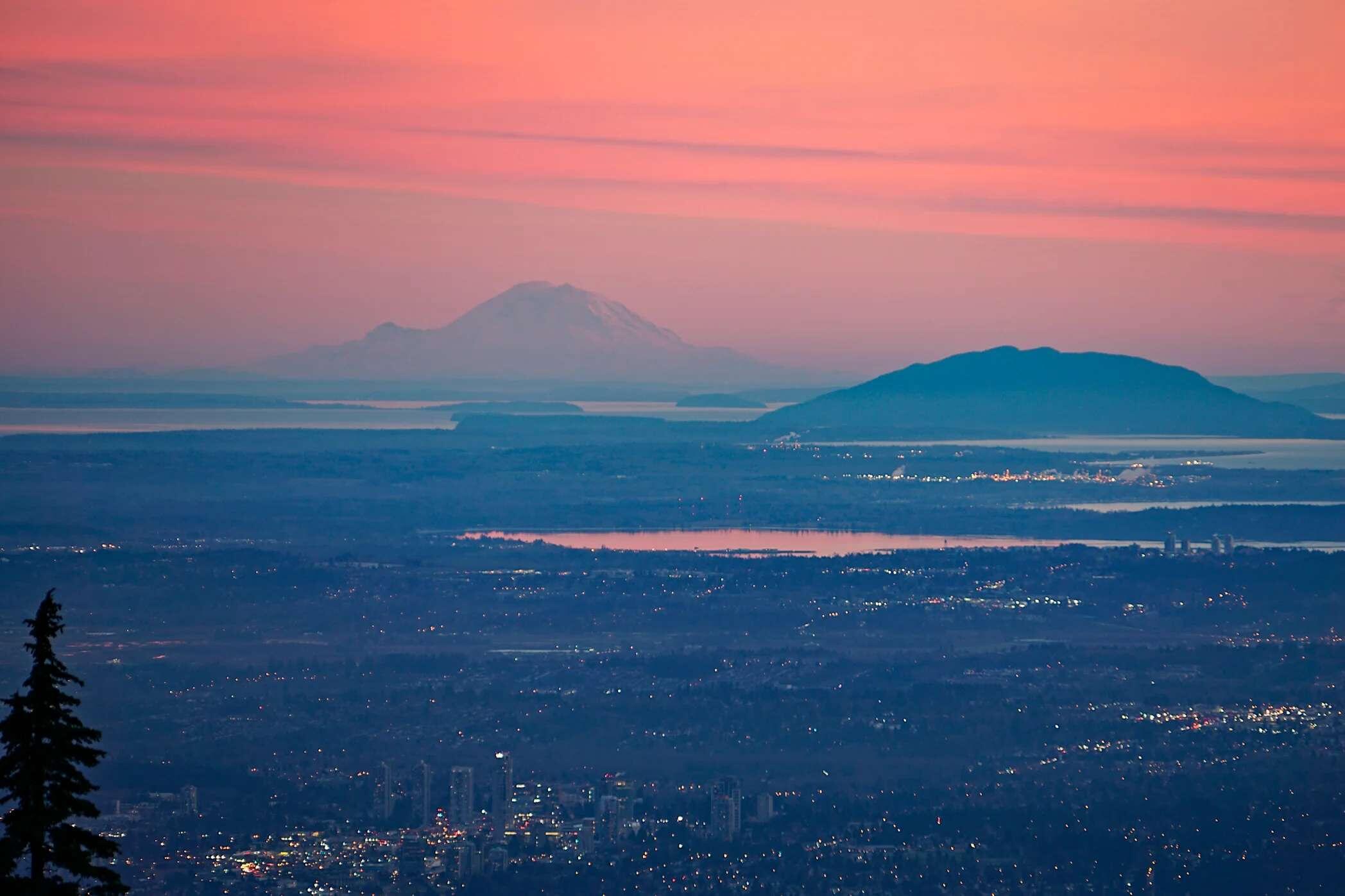
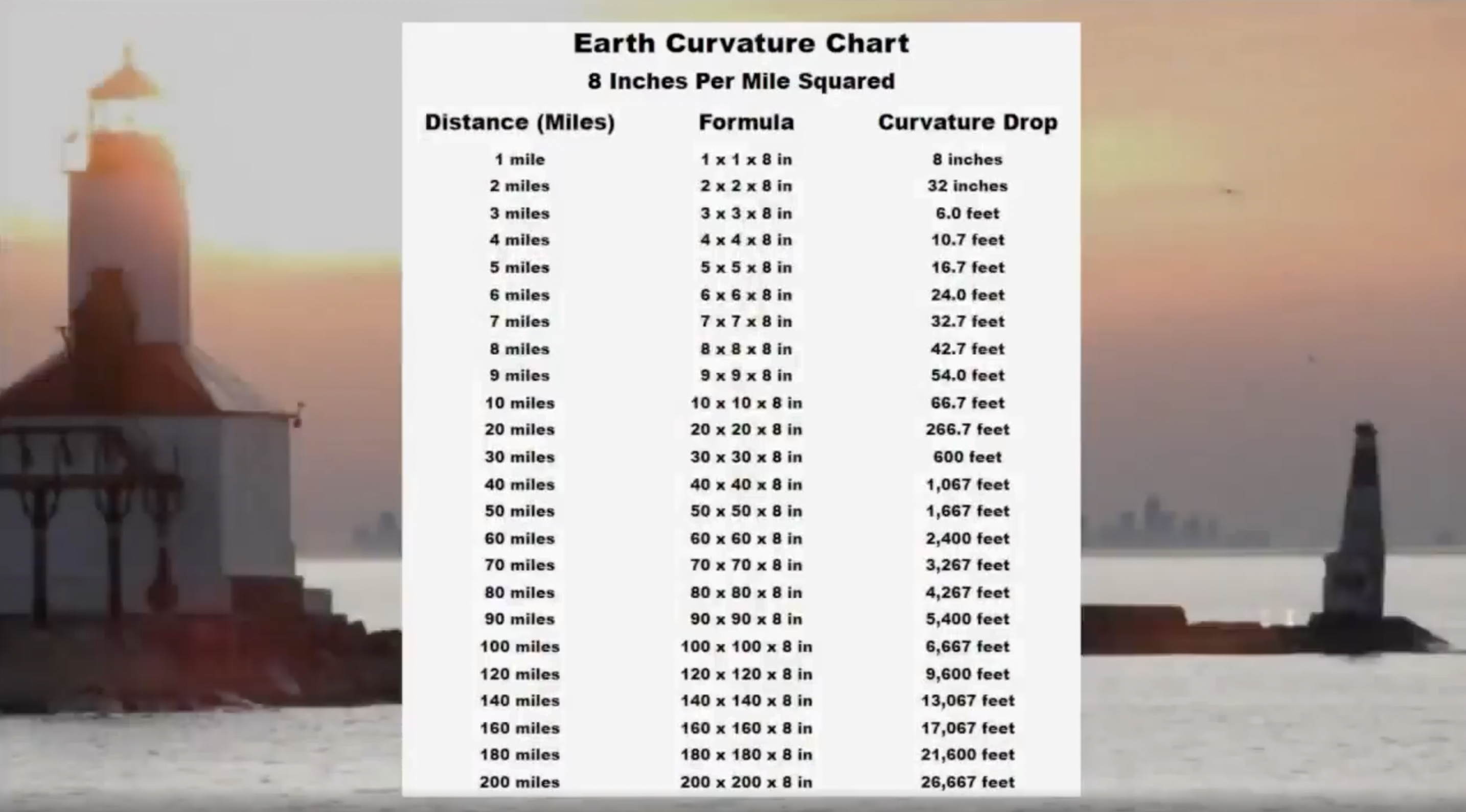
"content": "Lil quick test using some PNW landmarks I'm familiar with...\n\n(See reference chart of how much drop in elevation we should see due to earth's curvature over certain ground distances.)\n\nHere's a photo of Mt. Rainier from Vancouver B.C. Almost exactly 200 miles distance, which equal 5.05 miles of drop from curvature.\n\nTippy top of Mt. Rainier is 2.72 miles in height, so on net, from Vancouver B.C., that peak of the summit should be well hidden 2.33 MILES below ground level from the perspective of the photographer.\n\nYet you can see the BASE of the mountain, essentially bone-flat with Vancouver despite 200 miles of distance. That's mathematically impossible based on the globe model. #FlatEarth https://image.nostr.build/64156905afb7870f1017cadfd42610bb3c5e410482c4ad6e6595d2959a10145e.jpg\nhttps://image.nostr.build/1a893a0271ac3a508c747bbd645950aaf62b34fc99e3797ceb9a82ecd6ce3a3b.jpg\nnostr:nevent1qqsfj30ewvjj6k8ecc5tk2nkl9d33h5fqcwpxsj2cefwztkqk6feqpspz4mhxue69uhhyetvv9ujuerpd46hxtnfduhsygqqrzm7uvlmy5uyxcuuvt3f9lk8qznf4yas3m3hf3da49cunvu4vspsgqqqqqqsnzx3s4",
"sig": "9f619bcfea7b93191e5341799664a36d450f7c4a00a1ec9b8be84f0c4115ddb4f34bc306649ac1d3e2d37a42cfc70e70148d53bd138153d3ad24d5c15147f585"
}