Landfall Imminent For Powerful Hurricane Milton
Update (2030ET)
Milton is about to make landfall as a Category 3 storm on Wednesday evening on Florida's central west coast.
The eye wall of Hurricane Milton has arrived!!https://twitter.com/EdgarONealWX?ref_src=twsrc%5Etfw
— Reed Timmer, PhD (@ReedTimmerUSA) https://twitter.com/ReedTimmerUSA/status/1844153706176229886?ref_src=twsrc%5Etfw
"The northern eyewall of Hurricane Milton is beginning to move onshore of the Florida Gulf Coast near Tampa and St. Petersburg, where an Extreme Wind Warning is now in effect. Please shelter in place as these extremely dangerous hurricane-force winds overspread the region," NHC warned.
Hurricane https://twitter.com/hashtag/Milton?src=hash&ref_src=twsrc%5Etfw
— Spectrum Bay News 9 Weather (@bn9weather) https://twitter.com/bn9weather/status/1844155324422361394?ref_src=twsrc%5Etfw
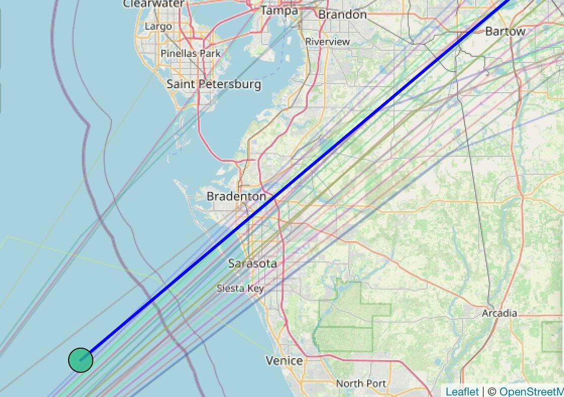
The storm's landfall location is between Bradenton and Sarasota.
Tornado mania across South Florida.
10/9 - As of 6pm:
55 Tornado Warnings issued today solely by NWS Miami.
98 Tornado Warnings issued today by NWS Tampa Bay, NWS Melbourne, and NWS Miami today.
At least 9 Confirmed Tornadoes today in our NWS Miami area (Preliminary). https://t.co/G1s6jWa944
— NWS Miami (@NWSMiami) https://twitter.com/NWSMiami/status/1844134821163041058?ref_src=twsrc%5Etfw
Half a million customers are without power.
514k electric customers are without power in https://twitter.com/hashtag/Florida?src=hash&ref_src=twsrc%5Etfw
nears landfall.
[2024-10-09 7:58 PM EDT]https://t.co/8cAFt3AeyM
— PowerOutage.us (@PowerOutage_us) https://twitter.com/PowerOutage_us/status/1844169882226786480?ref_src=twsrc%5Etfw
A dire warning from NWS about "catastrophic flash floods"...
https://twitter.com/hashtag/WPC_MD?src=hash&ref_src=twsrc%5Etfw
— NWS Weather Prediction Center (@NWSWPC) https://twitter.com/NWSWPC/status/1844158628577804327?ref_src=twsrc%5Etfw
Scenes from Sarasota:
Very sad situation now here in Sarasota looking out towards the outer barrier islands. Power flashes have now started dotting the sky, and Bird Key is being swallowed by extremely strong winds and storm surge as https://twitter.com/hashtag/Milton?src=hash&ref_src=twsrc%5Etfw
— Ben McMillan (@WeatherLiveTV) https://twitter.com/WeatherLiveTV/status/1844153236883898444?ref_src=twsrc%5Etfw
This is the scene currently in Sarasota, Florida at Tuttle Rd & Fruitville Road.
Landfall of https://twitter.com/hashtag/Milton?src=hash&ref_src=twsrc%5Etfw
— ☈ Chris Jackson ☈ (@ChrisJacksonSC) https://twitter.com/ChrisJacksonSC/status/1844162976175227209?ref_src=twsrc%5Etfw
Just before eight o'clock in Downtown Sarasota. Power flashes, shrieking winds, big gusts funneling between the buildings. https://twitter.com/hashtag/Hurricane?src=hash&ref_src=twsrc%5Etfw
— Josh Morgerman (@iCyclone) https://twitter.com/iCyclone/status/1844167736865456409?ref_src=twsrc%5Etfw
Live with https://twitter.com/NateTWN?ref_src=twsrc%5Etfw
— The Weather Network (@weathernetwork) https://twitter.com/weathernetwork/status/1844167287810748526?ref_src=twsrc%5Etfw
Live weather cameras:
* * *
Milton strengthened overnight into a devastating Category 5 hurricane with maximum sustained winds in excess of 160 mph. The National Hurricane Center reported early Wednseday that Milton was located about 300 miles southwest of Tampa, traversing the warm waters of the Gulf of Mexico towards the northeast at 14 mph.
"On the forecast track, the center of Milton will move across the eastern Gulf of Mexico today, make landfall along the west-central coast of Florida late tonight or early Thursday morning, and move off the east coast of Florida over the western Atlantic Ocean Thursday afternoon," NHC wrote in an advisory note.
The latest forecast states Milton will make landfall near Sarasota between 0200 ET and 0600 ET Thursday morning as a Category 4 storm.
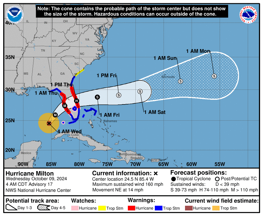
One of the main concerns across the Tampa to Sarasota region will be the storm's dangerous eye and eyewall unleashing record storm surges. Warnings have already been posted for much of Florida's western coast.
Storm surge plus wave heights. Not good https://t.co/SPpSM0o4MY
— The American Storm (@BigJoeBastardi) https://twitter.com/BigJoeBastardi/status/1843952559872217111?ref_src=twsrc%5Etfw
Not good.
Wow! Watch this catastrophic simulation of Hurricane Milton
Milton is predicted to hit as a Category 5 hurricane with storm surges up to 15 feet in the Tampa area then will move across Florida
If you are in Milton’s path with evacuation orders, leave now
Do NOT wait https://t.co/Nfv6LIQ8Bv
— Kylie Jane Kremer (@KylieJaneKremer) https://twitter.com/KylieJaneKremer/status/1843739071950270740?ref_src=twsrc%5Etfw
"Tampa is on a knife's edge, but Sarasota, Siesta Key, Venice, Englewood, Port Charlotte, and Punta Gorda continue to look to experience the worst of the storm surge under this scenario," Ben Noll, a meteorologist with New Zealand's National Institute of Water & Atmospheric Research, wrote on X.
The overnight ECMWF nudges slightly north with https://twitter.com/hashtag/Milton?src=hash&ref_src=twsrc%5Etfw
, with the eye forecast to pass near the southern end of Tampa Bay.
Tampa is on a knife's edge, but Sarasota, Siesta Key, Venice, Englewood, Port Charlotte, and Punta Gorda continue to look to experience the worst of the… https://t.co/DAqnVxHJ4v
— Ben Noll (@BenNollWeather) https://twitter.com/BenNollWeather/status/1843922745471750576?ref_src=twsrc%5Etfw
Noll continued.
As of early Wednesday, https://twitter.com/hashtag/Milton?src=hash&ref_src=twsrc%5Etfw
remained a category 5 storm with a central pressure of 907 hPa, continuing to rank in the top-10 most intense Atlantic hurricanes on record from a pressure perspective.
Landfall in https://twitter.com/hashtag/Florida?src=hash&ref_src=twsrc%5Etfw
— Ben Noll (@BenNollWeather) https://twitter.com/BenNollWeather/status/1843954531979387188?ref_src=twsrc%5Etfw
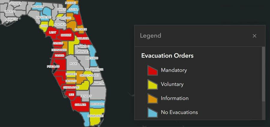
Since Sunday, evacuations in the state have been the largest since 2017.
According to the Florida Division of Emergency Management, here are the areas under mandatory evacuation orders:
Charlotte County; Citrus County; Collier County; Hillsborough County; Hernando County; Lee County; Levy County; Manatee County; Pasco County; Pinellas County; Sarasota County; St. John's County and Volusia County;
And voluntary evacuation orders:
Glades County; Okeechobee County; Dixie County; Hardee County; Miami-Dade County and Union County.
Evacuation order map:
GTFO.
Officials are urging residents along Florida's Gulf Coast to evacuate ahead of Hurricane Milton, with the Tampa mayor saying, "If you choose to stay in one of those evacuation areas, you're going to die." https://t.co/NTg683IJRH
— AccuWeather (@accuweather) https://twitter.com/accuweather/status/1843684227424075830?ref_src=twsrc%5Etfw
Massive evacuations in Florida due to Hurricane Milton. This is I-75 in Tampa. https://t.co/owHfH8v8sj
— T_CAS videos (@tecas2000) https://twitter.com/tecas2000/status/1843583287190851629?ref_src=twsrc%5Etfw
A mass evacuation is in progress in Sarasota, Florida, following the upgrade of Hurricane Milton to a Category 5. Here’s a look at the northbound traffic on I-75 as residents make their escape.https://twitter.com/MyRadarWX?ref_src=twsrc%5Etfw
— Jordan Hall (@JordanHallWX) https://twitter.com/JordanHallWX/status/1843338594691567668?ref_src=twsrc%5Etfw
Meanwhile, Tampa-area Sheriff Chad Chronister of the Hillsborough County Sheriff's Office told residents anyone who has not evacuated is "on their own."
https://cms.zerohedge.com/users/tyler-durden
Wed, 10/09/2024 - 20:30
https://www.zerohedge.com/weather/milton-barrels-towards-tampa-area-cat-5-hurricane